
Geosciences –
Geophysics, Seismology and Engineering
GEOPHYSICS BACKGROUND
The University of Kentucky – Department of Earth and Environmental Sciences – Geophysical Sciences Program has been conducting extensive geophysical characterizations of the PGDP and vicinity since 1992.
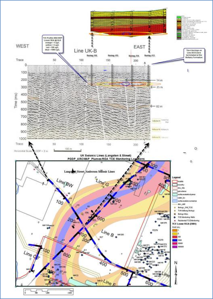
Dr. Ron Street, Ph.D. and graduate students Christina Langston & J.B. Harris evaluated historical geophysical data collected at the PGDP. Subsequently, they collected more than 17 km of shear wave (SH-wave) reflection data in the immediate vicinity of the PGDP in an area encompassing the TCE and 99Tc groundwater contaminant plumes (Langston, 1998).
The eventual 1998 release of the report “ACQUISITION OF SH-WAVE SEISMIC REFLECTION AND REFRACTION DATA IN THE AREA OF THE NORTHEASTWARD TRENDING CONTAMINANT PLUME AT THE PGDP” remains the single largest geophysical investigation conducted at the PGDP..
The “Langston” report identified the major structural features in bedrock underlying the PGDP along the collection lines. Data processing and filtering capabilities of the time allowed the bedrock displacement features to be tracked upward through overlying (younger) and more recent unconsolidated materials to the approximate surface of the Region Gravel Aquifer (RGA).
Rapid advances in geophysical data collection and interpolation capabilities began in the late 1990’s and continue today. Pre- and post-processing, filtering, new algorithms and rapid improvement of public and proprietary software allowed researchers to re-process “old” data. Data collected during the 1998 study has been re-processed over the course of two recent geophysical investigations to provide targets for additional field data collection.
The Department of Earth and Environmental Sciences (formerly Geological Sciences) began recent geophysical investigations at the PGDP in 2005. One M.S. thesis project, ‘Structural Features Related to PGDP Groundwater and Plumes” has been completed and a follow-up Ph.D. dissertation study has been completed ‘SH-Wave Imaging of Near Surface Controls on Contaminant Plume Migration.’
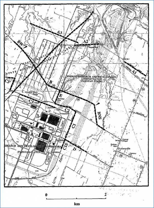
Langston (1998) geophysical study SH wave data collection lines (17km)
Project Team
Dr. Ron Street, Geological Sciences-Geophysics, University of Kentucky
Christina Langston, Ph.D. Student, Geological Sciences-Geophysics, University of Kentucky
J.B. Harris, Geological Sciences-Geophysics, University of Kentucky
Dr. Edward Woolery, Earth and Environmental Sciences- Geophysics, University of Kentucky
Project Documents
GEOPHYSICAL METHODS to SUPPORT SITE ACTIVITIES
University of Kentucky Earth and Environmental Science (EES) geophysical data collection and assessment thesis and dissertation projects have been instrumental in the development and application of SH-wave methods in the shallow sub-surface. From 2003 to 2014, the projects
expanded PGDP & vicinity geophysical data coverage and successfully applied two iterations of state-of-the-art data processing methods to define the upper and lower surfaces of the Lower Continental Deposits comprising the Regional Groundwater Aquifer (RGA). Both projects re-processed data collected by Langston (1998) and collected additional data on focused targets.
Through the additional data collection and use of two iterations of improved analytical software the Projects: 1) correlated shallow subsurface displacement features with the lateral extent of PGDP’s off-site Northwest and Northeast Plumes in the Regional Gravel Aquifer; 2) Utilized electrical resistivity along seismic lines to identify areas of decreased resistivity that correlate with structural features 3) Utilized electrical resistivity to identify a very shallow area of lower resistivity coincident with contaminated groundwater seep discharges in Little Bayou Creek; and 4) Applied a birefringence approach to identify ‘fast’ and ‘slow’ flow directions in the RGA material (see Al-Mayahi, 2013).
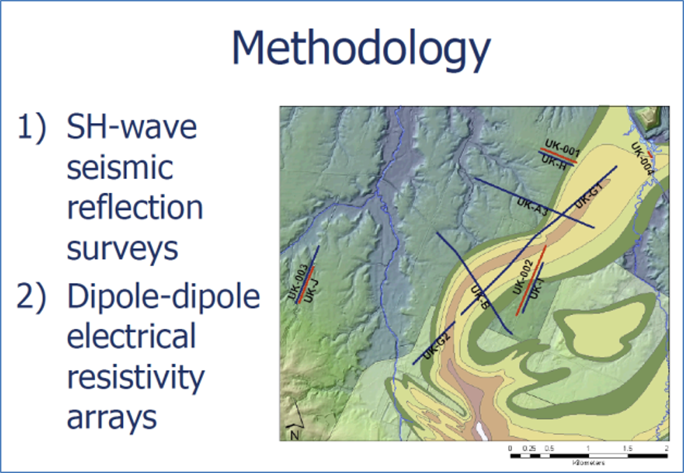
Locations of electrical resistivity survey data and additional seismic reflection survey data collected in the vicinity of the PGDP. (Blits, 2008)
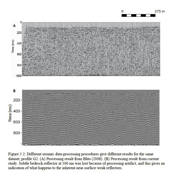
The Line G1 profiles from the 2008 Blits thesis (top) was updated using a state-of-the-art integrated processing algorithm for the Al-Mayahi dissertation (2013). (Al-Mayahi, 2013)
Correlation of seismic surveys with the lateral and vertical extents of the PGDP NW Plume. (KRCEE, 2008)
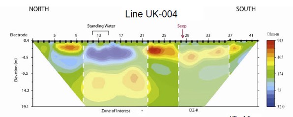
Electrical Resistivity Survey Line 004 collected adjacent (Line collected @ 20’ west) to LBC Seeps. Blue area illustrates a shallow area of lower resistivity coincident with the seeps. (Blits, 2008)
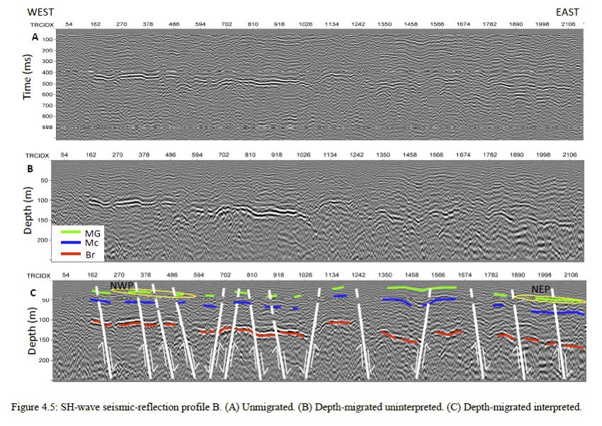
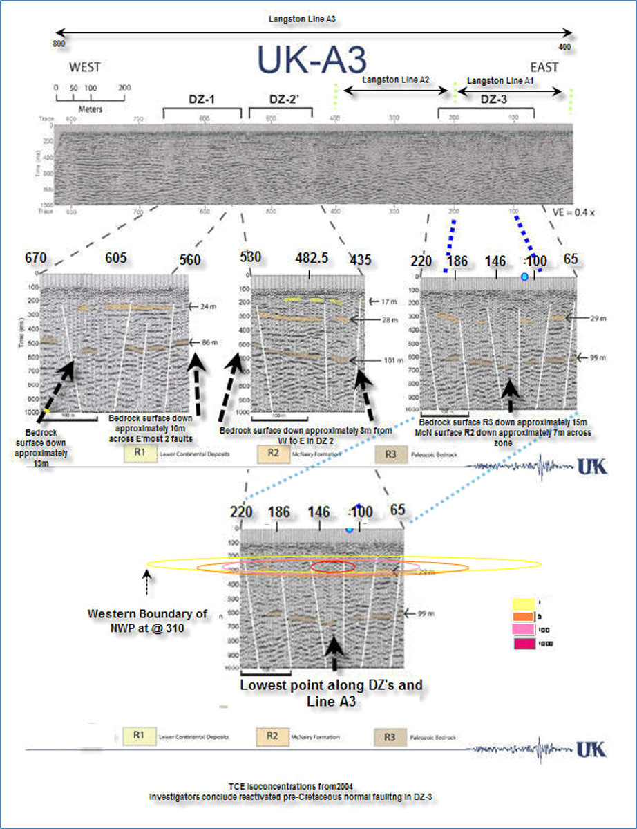
Seismic Line A profile produced using a state-of-the-art integrated processing algorithm. (Al-Mayahi, 2013)
Project Team
Dr. Edward Woolery, Geophysics Professor, UK-Earth and Environmental Sciences
Cora Blits, Graduate Student, UK-Earth and Environmental Sciences – Geophysics
Ali Al-Mayahi, Ph.D. Student, UK-Earth and Environmental Sciences – Geophysics
Project Documents
HOLOCENE INVESTIGATION
This Holocene Investigation was an in-depth Paleoseismic fault hazard investigation for a proposed expansion of the C-746-U landfill located at the Paducah Gaseous Diffusion Plant (PGDP), in Paducah, Kentucky. The purpose of the fault hazard investigation was to determine if Holocene-active fault displacement is present beneath the footprint of the proposed landfill expansion.
The Code of Federal Regulations (CFR), Subtitle D, Title 40, Part 258, subpart B (258.13) requires that disposal facilities (such as the C-746-U landfill and possible expansions) be located more than 200 feet from a fault that has had surface displacement within Holocene time (i.e., the past 11,000 years).
The planned expansion is located directly north of the present-day C-746-U landfill. Previous geophysical studies (Blackhawk 2003) within the PGDP site and vicinity identified possible northeast-striking faults beneath the proposed landfill expansion (Below). Prior to this investigation the existence, locations, and ages of these inferred faults have not been confirmed through independent subsurface exploration.
The Holocene Investigation geologic assessment included (a) review of relevant geologic and geotechnical data from the site vicinity, (b) analysis of detailed aerial photography, (c) field reconnaissance of the site vicinity and other important sites of previous investigations, (d) collection and stratigraphic analysis of 86 subsurface sediment cores, (e) laboratory chronological (age-dating) analyses, and (f) preparation of this report. These activities were completed at or above the accepted standard-of-practice for geologic investigations in the mid-continent region; overall this investigation represents an effort that exceeds previous levels of investigation for site-specific fault-rupture assessments in the mid-continent.
The investigation was completed as a collaborative effort involving local, regional, and national paleoseismology subject-matter experts; William Lettis & Associates, Inc., Earth and Environmental Sciences (Geology) Department of the University of Kentucky, and the University of Chicago.
Technical peer review of the approach, methods, preliminary results and final conclusions of this study have been provided by geoscientists and paleoseismic technical experts with the Kentucky Geological Survey, the Illinois Geological Survey, the University of Memphis, the University of Illinois – Champaign, Science Applications International Corporation (SAIC), and M. Tuttle & Associates.
Based on extensive data collection and analysis followed by paleoseismic subject-matter-expert review there is NOT evidence of Holocene Displacement in the study area, i.e. displacement of materials within the last 11,000 years. If late Quaternary displacement has occurred beneath the site, the most-recent displacement occurred following deposition of the Unnamed Intermediate Silt between approximately 53,600 and 75,500 years ago.
The Holocene Investigation Report presents the findings of a fault hazard investigation for a proposed expansion of the C-746-U landfill located at the Paducah Gaseous Diffusion Plant (PGDP), in Paducah, Kentucky.
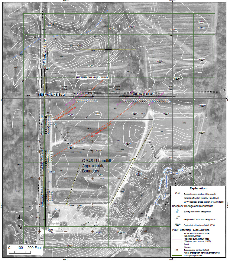
Aerial Photo Map of PGDP Landfill Complex, Underlying Interpreted Faults (Blackhawk 2003), and Holocene Project Data Collection Points.
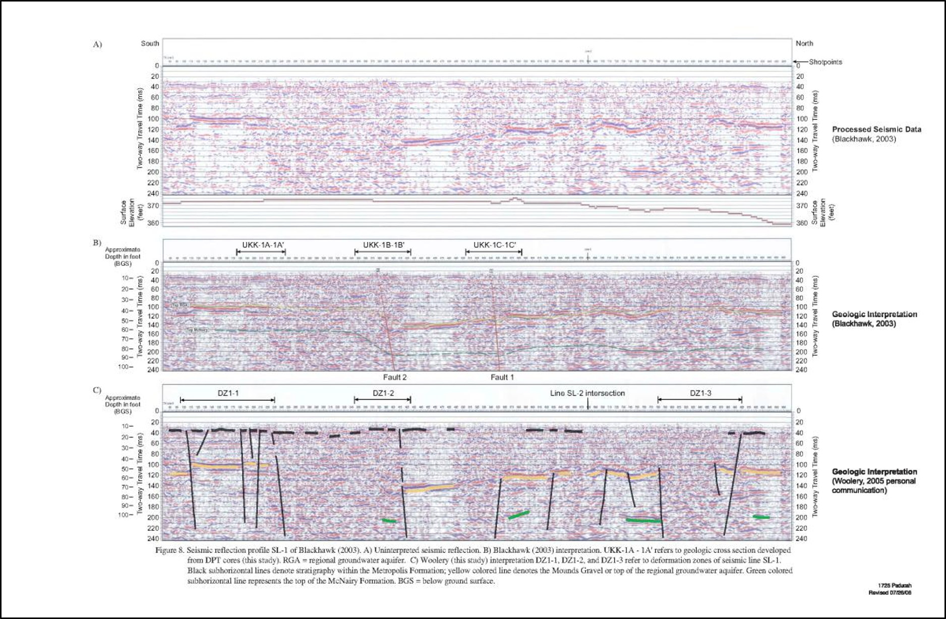
Seismic line profiles (Blackhawk & Woolery) from line SL-1 at the C-746-U landfill Expansion
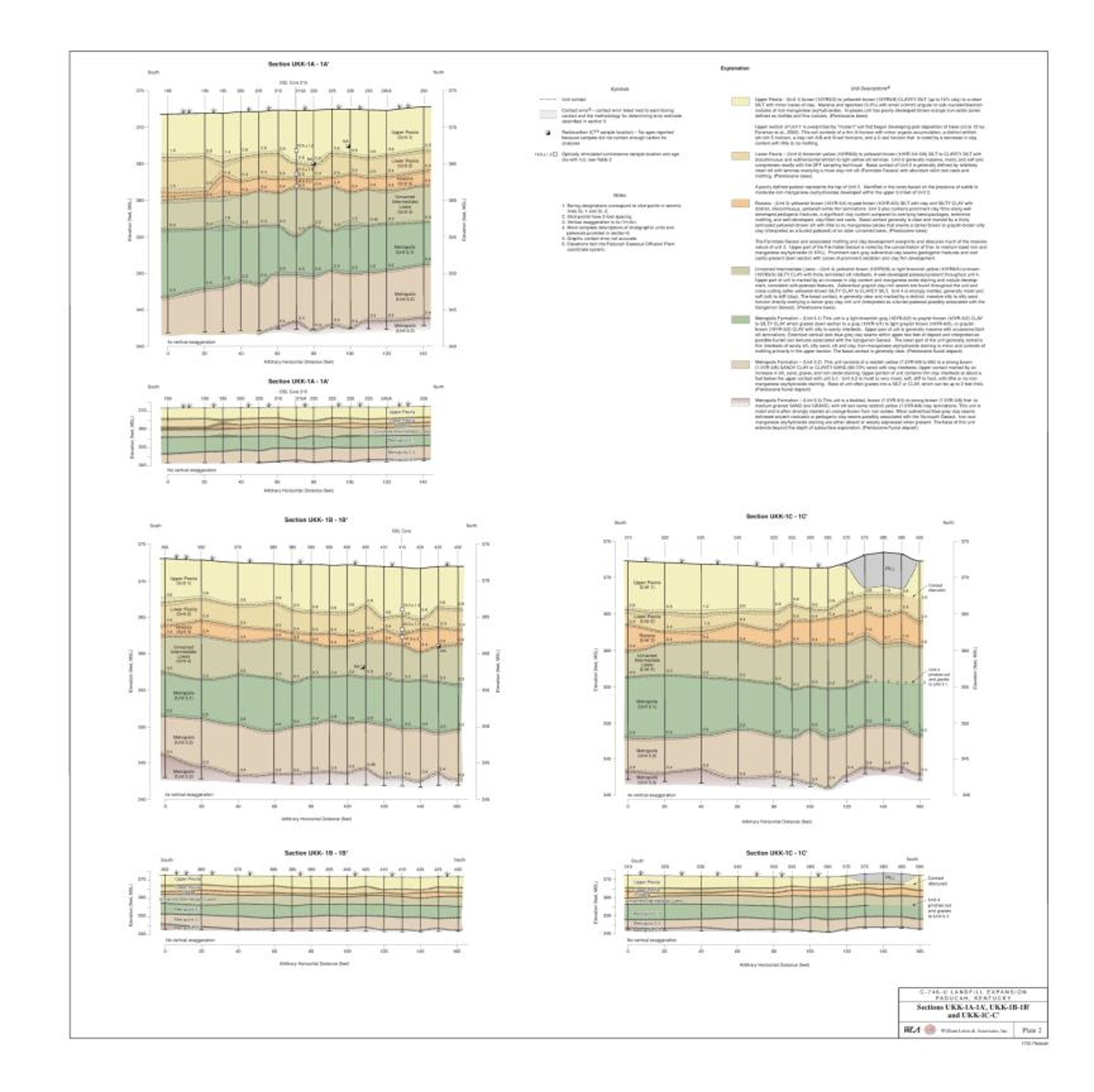
Holocene Investigation Line Sections 1A, 1B and 1C Illustrate Scale and Exaggerated Soil Unit Contacts
Project Team
Dr. Edward Woolery, Geophysics Professor, Earth and Environmental Sciences, University of Kentucky
Dr. Zhenming Wang, Seismologist and Section Head (Geological Hazards), Kentucky Geological Survey, University of Kentucky
Dr. Martitia (Tish) Tuttle – Tuttle and Associates (formerly Univ of Maryland)
Dr. Roy Van Arsdale – University of Memphis
Mr. John Nelson – Illinois Geological Survey
Dr. Leon Follmer – Illinois Geological Survey
Dr. Bill Lettis, Lettis & Assoc. / Walnut Grove, CA
Dr. John Baldwin, Lettis & Assoc. / Walnut Grove, CA
Dr. Keith Kelson, Lettis & Assoc. / Walnut Grove, CA
Robert Givler, Lettis & Assoc. / Walnut Grove, CA
Sean Sundermann, Lettis & Assoc. / Walnut Grove, CA
Ken Davis, Paducah Remediation Services
Dr. Dave Amick (SAIC-Augusta)
Mr. Marshall Davenport – Jacobs Engineering, Oak Ridge
Steve Hampson – KRCEE
Project Documents
SEISMIC SCIENCES: BACKGROUND AND ISSUES
Far western Kentucky lies within the northeastern extent of the New Madrid Seismic Zone (NMSZ), an area that holds intrigue for historians, geologists, geophysicists, engineers, seismologists and paleoseismologists. New Madrid, Missouri sits astride one of the notable great bends in the Mississippi River, Kentucky Bend. New Madrid also marks the epicenter of
the Great New Madrid Earthquakes of 1811-12. More than 1,000 earthquakes occurred during those 2 years with the strongest up to magnitude 8. The ground liquefied, sand boiled to the surface, the mighty Mississippi flowed backwards and the bootheel of Kentucky, across the river from New Madrid, raised and fell depending upon where you were standing. The largest earthquakes of 1811-12 remain the strongest earthquakes to have occurred in the continental U.S. away from plate margin subduction zones.
The PGDP and the city of Paducah are located 55+ miles northeast of New Madrid, Mo. and straddle 3 known seismic zones: the Wabash Valley Seismic Zone (WVSZ), Fluorspar Area Fault Complex (FAC or FAFC) and the NMSZ.
The FAC, which is the zone in closest proximity to the PGDP, has not been active in the last 55,000 years. Portions of the WVSZ have been active in the last 6,000 years and the NMSZ remains active today. PGDP’s location relative to known seismic zones prompted the 1988 installation of seismic joints in enrichment process piping to ensure system integrity in the event of modern seismic events in the region.
For public officials, engineers, seismic scientists, and local folk, intrigue may be replaced by the challenges of defining and understanding the history and occurrence of earthquakes in the region, their likelihood of recurrence, and the bedrock to surface response at given locations. Defensible and actionable characterization of the seismic hazards and resultant risks inherent to specific locations remain a challenge for all, especially the technical and regulatory community.
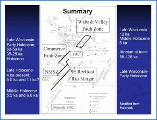
Seismic features in the vicinity of the PGDP.
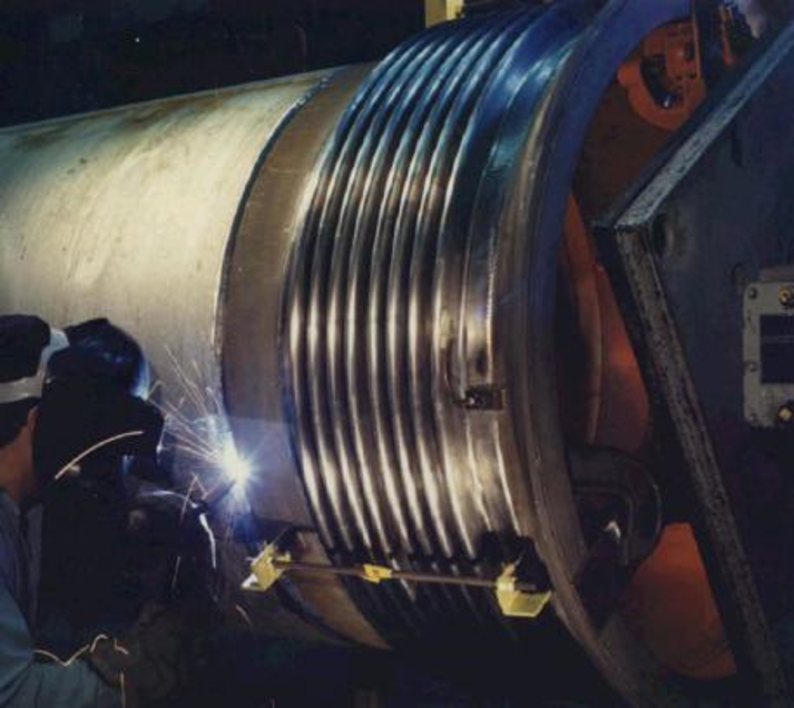
Seismic joints added to Enrichment Process piping in 1998 as part of seismic engineering safety measures.
Project Team
Dr. Edward Woolery – Geophysics Professor, Earth and Environmental Sciences, University of Kentucky
Dr. Zhenming Wang – Seismologist and Section Head (Geological Hazards), Kentucky Geological Survey
Alice Orton – Graduate Student, Earth and Environmental Sciences, University of Kentucky
Jonathan McIntyre – Kentucky Geological Survey, University of Kentucky
Cora Blits – Graduate Student, UK-Earth and Environmental Sciences – Geophysics
Steve Hampson – KRCEE
Project Documents
| Public Meeting Presentation | Overview of Report “Seismic Issues for Consideration in Site Selection and Design of a Potential On-Site CERCLA Waste Disposal Facility at the Paducah Gaseous Diffusion Plant“, Presentation to PGDP Site Specific Advisory Board (SAAB), 2001. |
| Professional Publication | Wang, Z. (compiler), 2003, Proceedings of The Kentucky NEHRP Seismic Hazards and Design Maps Workshop, November 18, 2002, Lexington, Kentucky, Kentucky Geological Survey, ser. 12, Special Publication 5, 38p. |
| Symposium Presentation | Anderson, Cora, Observed Seismicity in the Jackson Purchase Region of Western Kentucky Between January 2003 and June 2005, Proceedings of the 2007 KRCEE Technical Symposium. |
| Symposium Presentation | Woolery, E.W., Western Kentucky Seismicity and Neotectonics: Integrated Geophysical and Geological Solutions, Proceedings of the 2007 KRCEE Technical Symposium. |
| Project Brief | List of Kentucky Geological Survey and UK Department of Earth and Environmental Sciences Activities Related to the Seismic Hazard Assessment at PGDP, KRCEE p21.8 2007d. |
| Congressional Briefing | Cobb, J.C., Seismic Policy and Regulation in Western Kentucky, Kentucky Congressional Office Briefing, July 2009. |
| Journal Article | Wang, Z., 2011, Seismic Hazard Assessment: Issues and Alternatives, Pure and Applied Geophysics, 168: 11–25 |
| Book Chapter | Wang, Z., 2014, Seismic Design in Western Kentucky: Issues and Alternatives. Seismic Hazard Design Issues in the Central United States, in Beavers, J., and Uddin, N., eds, Seismic Hazard Design Issues in the Central United States, Chapter 9, p 111-141, doi: 10.1061/9780784413203.ch09. |
| Professional Meeting Presentation | Wang, Z., 2014, Comparison of Design Ground Motion between Coastal California and the Central United States, Proceedings of the Tenth U.S. National Conference on Earthquake Engineering Frontiers of Earthquake Engineering, July 21-25, 2014, Anchorage, Alaska (DOI: 10.4231/D3NP1WJ9K), p. 8020–8030. |
| Thesis | Orton, A., SCIENCE AND PUBLIC POLICY OF EARTHQUAKE HAZARD MITIGATION IN THE NMSZ, M.S. Thesis, 2014 (http://uknowledge.uky.edu/ees_etds/19) |
| Professional Publication | Orton, A., Woolery, E., and Wang, Z.W., Earthquake hazard mitigation the NMSZ (Report of Investigations 32, Series XII, Kentucky Geological Survey (KGS) Publication, 2016. |
| Journal Article | Wang, Z., Orton, A., Wang, L., and Woolery, E.W., 2016, Seismic hazard mapping and mitigation policy development in the central United States and western China, Natural Hazards, 81: 387–404, doi:10.1007/s11069-015-2086-y. |
KENTUCKY STRONG MOTION SEISMIC MONITORING NETWORK
The Kentucky Seismic and Strong Motion Monitoring Network (KSSMN) is a series of 26 monitoring stations across the Commonwealth.
KSSMN can monitor any earthquake with a magnitude 2.0 or larger within Kentucky and includes monitoring of significant blasts, mine collapses, and explosions.
Data from 12 seismic stations are continuously recorded as part of the “near” real-time monitoring system. The system “triggers” to record events of note to be reviewed. The real-time network utilizes the Kentucky Early Warning System (KEWS) for data transmission.
Data from remaining stations are downloaded weekly via modem (weekly) or are downloaded manually on a quarterly basis and reviewed.
KSSMN recorded numerous earthquakes since January 1, 2006. Instruments are available to rapidly begin aftershock studies for large events.

Kentucky Seismic and Strong Motion Network (KSSMN) Installation Locations. Location VSAP is located in the West Kentucky Wildlife Management Area adjacent to the PGDP.
Project Team
Dr. Edward Woolery, Geophysicist, Earth and Environmental Sciences, University of Kentucky (Co-PI)
Dr. Zhenming Wang, Geological Hazards Section Head, Kentucky Geological Survey, University of Kentucky (Co-PI)
Dr. Seth Carpenter, Geologic Hazards Section, Kentucky Geological Survey, University of Kentucky
Dr. Ron Street, Associate Professor, Department of Geological Sciences (Earth and Environmental Sciences), University of Kentucky
Jonathon McIntyre, Environmental Hazards Section, Kentucky Geological Survey, University of Kentucky
Cora Anderson-Blits, Graduate Student, Earth and Environmental Sciences, University of Kentucky
Steve Hampson, Associate Director, Kentucky Research Consortium for Energy and Environment (KRCEE), Center for Applied Energy Research, University of Kentucky
Project Documents
CENTRAL UNITED STATES SEISMIC OBSERVATORY (CUSSO)
The Central United States Seismic Observatory (CUSSO) was installed and is monitored in collaboration with DOE, USGS, and KGS to characterize seismicity and soil column response from bedrock to ground surface in the centroid of the New Madrid Seismic Zone.
The 1900-foot deep CUSSO installation located at Sassafras Ridge, near the “bootheel” of Kentucky, is instrumented to monitor three (3) subsurface horizons. Data collected from CUSSO will be used to refine models used by architects and engineers to design ground-motion safety features.
After 15 years of operation, CUSSO received maintenance upgrades in 2020 and 2021. The KGS Hazards Section publishes semi-annual reports summarizing CUSSO and network data collection efforts and research findings.
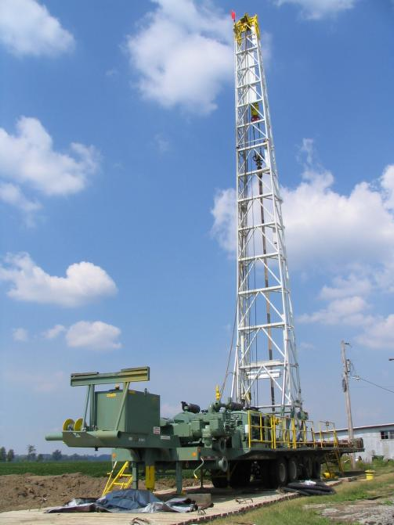
CUSSO Installation at Sassafras Ridge, Kentucky.
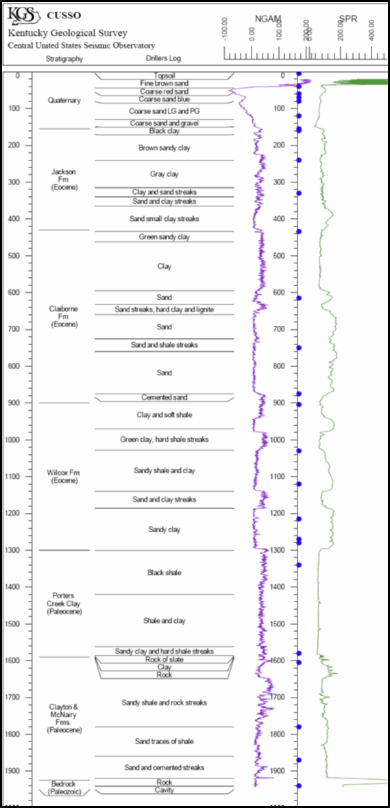
CUSSO Stratigraphic and geophysical well log interpretations. Stratigraphic interpretation from cuttings at the well head.
Project Team
Dr. Edward Woolery, Geophysicist, Earth and Environmental Sciences, University of Kentucky
Dr. Zhenming Wang, Geological Hazards Section Head, Kentucky Geological Survey, University of Kentucky
Dr. Ron Street, Associate Professor, Department of Geological Sciences (Earth and Environmental Sciences), University of Kentucky
Dr. Seth Carpenter, Geologic Hazards Section, Kentucky Geological Survey, University of Kentucky
Jonathon McIntyre, Environmental Hazards Section, Kentucky Geological Survey, University of Kentucky
Steve Hampson, Associate Director, Kentucky Research Consortium for Energy and Environment (KRCEE), Center for Applied Energy Research, University of Kentucky
Project Documents
SEISMIC HAZARD AND RISK ASSESSMENT
Seismic Hazard and Risk Assessment projects included research into, development of, and recommendations for the application of seismic hazard assessment methods for the Jackson Purchase Region of western Kentucky.
Project Team
Dr. Zhenming Wang, Geological Hazards Section Head, Kentucky Geological Survey, University of Kentucky (Co-PI)
Dr. Edward Woolery, Geophysicist, Earth and Environmental Sciences, University of Kentucky (Co-PI)
Dr. Seth Carpenter, Geologic Hazards Section, Kentucky Geological Survey, University of Kentucky
Dr. Baoping Shi, Postdoctoral Researcher, Kentucky Geological Survey, University of Kentucky
Alice Orton, M.S. Student, Earth and Environmental Sciences, University of Kentucky
Steve Hampson, Associate Director, Kentucky Research Consortium for Energy and Environment (KRCEE), Center for Applied Energy Research, University of Kentucky
Project Documents
| Workshop Presentation | Woolery., E.W., SEISMIC INVESTIGATION: Earthquake Input Parameters for the PGDP Region, Workshop Presentation, JULY 2004 |
| Professional Meeting Poster | Wang, Z., Woolery, E.W., Shi, B., The Vertical Strong-Motion Stations of the Kentucky Strong Motion Network, Seismological Society of America, 2004 Eastern Section Annual Meeting, Poster Presentation, 2004 (KRCEE p11.8 2004d) |
| Professional Meeting Presentation | Wang, Z., E.W. Woolery, B. Shi, and J. D. Kiefer, 2004, What is the Maximum Considered Earthquake Ground Motion (MCE)?, the 2004 EERI Annual Meeting, February 4-7, 2004, Los Angeles, CA. |
| Professional Meeting Presentation | Wang, Z., E.W. Woolery, B. Shi., and J.D. Kiefer, 2004, IBC and IRC 2000 and Seismic Hazard Assessment in the Central United States: An Example of Miscommunication between the Policy-Makers and Seismologists, the 76th Annual Meeting of the Eastern Section of the Seismological Society of America, Blacksburg, Virginia, October 31-November 2, 2004. |
| Professional Meeting Presentation | Wang, Z., E.W. Woolery, B. Shi, and J. D. Kiefer, 2004, Some Issues with Probabilistic Seismic Hazard Analysis in the Central and Eastern United States, the 2004 Seismological Society of America, Palm Spring, California, April 14-16, 2004. |
| Professional Meeting Presentation | Wang, Z., 2005, Role of the Kentucky Geological Survey in Implementing IBC-2000 and IRC-2000 in Kentucky: Better Communication of Seismic Hazard and Risk, AGU 2005 Fall Meeting, San Francisco, CA., December 5-9, 2005 (invited). |
| Professional Meeting Presentation | Wang, Z., 2005, A Clear Definition of Seismic Hazard and Risk: A Basis for Hazard and Risk Assessment, Communication, and Management, AGU 2005 Fall Meeting, San Francisco, CA., December 5-9, 2005. |
| Journal Article | Wang, Z. and L. Ormsbee, 2005, Comparison between probabilistic seismic hazard analysis and flood frequency analysis, EOS, Trans., AGU, 86: 45, 51-52 |
| Professional Meeting Presentation | Anderson, C., Z. Wang, and E. Woolery, Observed Seismicity in the Jackson Purchase Region of Western Kentucky between January 2003 and June 2005, The 77th Annual Meeting of the Eastern Section of the Seismological Society of America, Memphis, Tennessee, October 3-4, 2005. |
| Professional Meeting Presentation | Wang, Z., 2005, Seismic Hazard and Risk Assessment and Communication in the Central and Eastern United States, The 77th Annual Meeting of the Eastern Section of the Seismological Society of America, Memphis, Tennessee, October 3-4, 2005. |
| Professional Meeting Presentation | Wang, Z., E.W. Woolery, D. Yuan, and L. Wang, 2005, Comparison between the Active Faults in the New Madrid Seismic Zone of the Central United States and Gansu Province in Northwestern China, the 77th Annual Meeting of the Eastern Section of the Seismological Society of America, Memphis, Tennessee, October 3-4, 2005. |
| Journal Article | Wang, Z., 2005, Reply to “Comment on ‘Comparison between probabilistic seismic hazard analysis and flood frequency analysis’ by Zhenming Wang and Lindell Ormsbee” by R. M. W. Musson, EOS, Trans., AGU, 86: 354. |
| Journal Article | Wang, Z., 2005, Reply to “Comment on ‘Comparison between probabilistic seismic hazard analysis and flood frequency analysis’ by Zhenming Wang and Lindell Ormsbee” by Thomas L Holzer, EOS, Trans., AGU, 86: 303. |
| Journal Article | Wang, Z., B. Shi, and J. Kiefer, 2005, Comment on “How Can Seismic Hazard around the New Madrid Seismic Zone Be Similar to that in California?” by Arthur Frankel, Seismological Research Letters, 76: 472-477. |
| Professional Meeting Paper | Wang, Z., 2006, Understanding Seismic Hazard and Risk Assessments: An Example in the New Madrid Seismic Zone of the Central United States, Proceedings of the 8th National Conference on Earthquake Engineering, April 18-22, 2006, San Francisco, CA. (KRCEE p11.1, 2006) |
| Journal Article | Wang, Z., 2006, Probabilistic Seismic Hazard Analysis: A New Approach (submitted to the Bulletin of Seismological Society of America) |
| Professional Meeting Presentation | Wang, Z., 2006, Seismic Safety Regulations in Western Kentucky: The Role of Geology in Public Policy, Geologic Society of America – Southeastern Section, 55th Annual Meeting, March 23-24, 2006, Nashville, TN. (KRCEE p11.7, 2006d) |
| Journal Article | Wang, Z., 2006, Understanding Seismic Hazard and Risk Assessments: An Example in the New Madrid Seismic Zone of the Central United States, Proceedings of the 8th National Conference on Earthquake Engineering, April 18-22, 2006, San Francisco, CA. |
| Project Report | Wang, Z., E.W. Woolery, Preliminary Report on Seismic Hazard Assessment at Paducah Gaseous, KRCEE 11.5 2006. |
| Professional Meeting Presentation | Cobb, J, and Z. Wang, Kentucky Seismic Hazard Mapping Issues, the USGS national seismic hazard maps, the CEUS workshop, May 9-10, 2006, Cambridge, MA. |
| Presentation Abstract | Wang, Z., Seismic Safety Regulations in Western Kentucky: The Role of Geology in Public Policy (Presentation Abstract), Southeastern Section of the Geological Society of America, Paper No. 26-7, March 2006 |
| Professional Meeting Presentation | Wang, Z., “Seismic Hazard and Risk in Kentucky”, Kentucky Geotechnical Engineering Group, Frankfort, Kentucky, January 10, 2006. |
| Book Chapter | Wang, Z., 2006, Seismic Hazard and Risk Assessment in the Intraplate Environment: The New Madrid Seismic Zone of the Central United States, GSA Book, Continental Intraplate Earthquakes: Science, Hazard, and Policy Issues. (KRCEE p11.4 2007) |
| Symposium Presentation | KRCEE-ZW02_Probabilistic and Deterministic Seismic Hazard Assessment, KRCEE TECHNICAL SYMPOSIUM, 2007 |
| Project Report | Final Report Seismic Hazard Assessment at the PGDP, KRCEE p11.6 2007 |
| Professional Meeting Presentation | Wang, Z., Woolery E.W., Challenges in Seismic Hazard Assessment for the PGDP KRCEE Symposium, October 2007 |
| Project Brief | Wang, Z., A Short Note on Probabilistic Seismic Hazard Analysis, KRCEE p.11.2, 2007 |
| Activities Summary (2007) | Wang, Z., Woolery, E.W., KGS – Earth and Environmental Sciences Activities Related to the Seismic Hazard Assessment, KRCEE 21.8 2007d |
| Journal Article | Wang, Z., 2008, A technical Note on Seismic Microzonation in the Central United States, Journal of Earth System Science, 117(S2): 749–756. |
| Professional Meeting Presentation | Wang, Z., 2008, Understanding seismic hazard and risk: A gap between engineers and seismologists, Proceedings of the 14th World Conference on Earthquake Engineering, October 12-17, 2008, Beijing, China, Paper No. S27-001,11 p. |
| Special Publication | Wang, Z., and E.W. Woolery, 2008, Seismic Hazard Assessment of the Paducah Gaseous Diffusion Plant, Kentucky Geological Survey, ser. 12, Special Publication 9, 37p. Above Project Report KRCEE p11.5, 2007. |
| Meeting Poster | Wang, Z., Extreme Ground Motion at Yucca Mountain A Statistical Result, KRCEE p11.9 2008d. |
| Journal Article | Wang, Z., 2009, Seismic Hazard vs. Seismic Risk, Seismological Research Letters, 80: 673–674. |
| Journal Article | Macpherson, K.A., Woolery, E.W., Wang, Z., and Liu, P., 2010, Three-Dimensional Long Period Ground Motion Simulations in the Upper Mississippi Embayment, Seismological Research Letters, 81: 391–405. |
| Journal Article | Wang, Z., 2010, Ground Motion for the Maximum Credible Earthquake in Kentucky, Kentucky Geological Survey, ser. 12, Report of Investigations 22, 9p. |
| Professional Meeting Presentation | Wang, Z., 2011, Seismic Risk Assessment and Application in the Central United States, Proceedings of the GeoRisk 2011 Conference, June 26 – 28, 2011, Atlanta, GA, p. 1020–1027. |
| Journal Article | Wang, Z., 2011, Seismic Hazard Assessment: Issues and Alternatives, Pure and Applied Geophysics, 168: 11–25. |
| Journal Article | Wang, Z., and Cobb, J.C., 2012, A critique of probabilistic versus deterministic seismic hazard analysis with special reference to the New Madrid seismic zone, in Cox, R.T., Tuttle, M.P., Boyd, O.S., and Locat, J., eds., Recent Advances in North American Paleoseismology and Neotectonics East of the Rockies: Geological Society of America Special Paper 493, p. 259–275, doi:10.1130/2012.2493(13). |
| M.S. Thesis | Orton, A.M., Science and Public Policy of Hazard Mitigation in the New Madrid Seismic Zone, M.S. Thesis, University of Kentucky, 2014 |
| Journal Article | Wang, Z., 2015, Predicting or Forecasting of Earthquake and the Resulting Ground Motion Hazards: A Dilemma for Earth Scientists, Seismological Research Letters, 86: 1–5. |
| Professional Meeting Presentation | Wang, Z., 2015, the USGS National Seismic Hazard Mapping Project: Issues and Improvements, Proceedings of the ATC/USGS Seismic Hazard User-Needs Workshop, September 21-22, 2015, Menlo Park, California. |
| Project Report (KGS) | Orton, A., Wang, Z., Woolery, E.W., Seismic Hazard Mitigation in the New Madrid Seismic Zone – Science and Public Policy, Kentucky Geological Survey Report of Investigations 32, Series XII, 2016. |
| Journal Article | Carpenter, N.S., Wang, Z., Woolery, E.W., and Rong, M., 2018, Estimating site response with recordings from deep boreholes and HVSR: Examples from the Mississippi Embayment of the central United States, Bulletin of Seismological Society of America, 108: 1199–1209, doi:10.1785/0120170156 |
| Journal Article | Zhu, Y., Wang, Z., Carpenter, N.S., Woolery, E.W., and Haneberg, W.C., 2021, Mapping fundamental-mode site periods and amplifications from thick sediments: An example from the Jackson Purchase Region of western Kentucky, central United States, Bulletin of Seismological Society of America, 111, 1868–1884, doi:10.1785/0120200300. |
| Book Chapter | Wang, Z., Carpenter, N.S., and Woolery, E.W., 2022, Chapter 17 – Scenario-based seismic hazard analysis and its application in the central United States, in Panza, G., Kossobokov, V. G., Laor, E. and De Vivo B., eds, Earthquake and Sustainable Infrastructure, p. 349–371, doi:10.1016/B978-0-12-823503-4.00035-X (Elsevier). |
SEISMIC UPDATE REPORTS
Seismic update reporting is an ongoing annual to semi-annual project.
Reports update the status of seismic monitoring and data collection related to the PGDP, the New Madrid Seismic Zone and the Jackson Purchase Region. In general, the reports focus on seismic monitoring and data collection conducted at CUSSO & the Kentucky Seismic and Strong Motion Monitoring Network (KSSMN) including station VSAP located adjacent to the PGDP in the West Kentucky Wildlife Management Area. Developments and recommendations for the application of seismic hazard assessment methods for the Jackson Purchase Region of western Kentucky are also included in the Update Reports.
Project Team
Dr. Zhenming Wang, Geological Hazards Section Head, Kentucky Geological Survey, University of Kentucky (Co-PI)
Dr. Edward Woolery, Geophysicist, Earth and Environmental Sciences, University of Kentucky (Co-PI)
Dr. Seth Carpenter, Geologic Hazards Section, Kentucky Geological Survey, University of Kentucky (Co-PI)
Steve Hampson, Associate Director, Kentucky Research Consortium for Energy and Environment (KRCEE), Center for Applied Energy Research, University of Kentucky
Project Documents